User Interface
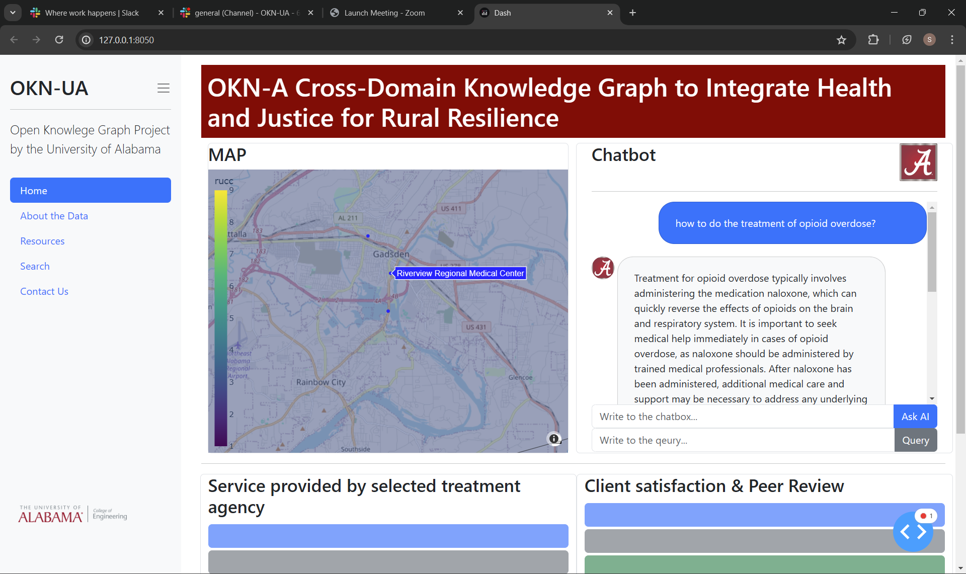
The app interface has three main components: a real-time map, a chatbot interface, and clinic information query boxes. When a user enters information into the chatbot, it classifies the questions into different categories and runs the appropriate LLM (Large Language Model) routing for each type of question. The map zooms in on the relevant location for questions associated with geolocated data in the database and displays the related clinic and services. The clinic details, including reviews and services, are retrieved from Google Maps and the clinic's website, which is crawled for information. This data is added to the database for future queries, eliminating the need to fetch it from Google Maps again.
Tools
We used Dash Plotly to construct the web app. The source code can be found at Shengting Cao repo.
Setting Up the Environment
- Create a new environment:
conda create -n OKN python=3.10 - Install Dash:
pip install dash - Install pandas:
pip install pandas
Useful Links
- Dash Template: Dash Gallery Portal
- Theme Documentation: Dash Theme Explorer
Project Layout
OKN/
  ├── assets/
  ├── Datasets/  # For survey data
  ├── pages/
  ├── app.py
  └── README.md
Multipage Design Reference
Refer to Dash's documentation for Multipage Design.
Mapbox Styles
To customize the map style, use the following in fig.update():
"open-street-map", "carto-positron", "carto-darkmatter",
"stamen-terrain", "stamen-toner", "stamen-watercolor",
"white-bg", "basic", "streets", "outdoors",
"light", "dark", "satellite", "satellite-streets"
GeoJSON Resources
- USDA Rural-Urban Continuum Codes (2013): USDA Link
- USA State GeoJSON: GitHub Link
- USA County GeoJSON: GitHub Link
PostgreSQL Setup
- Install the required libraries:
pip install dash psycopg2 sqlalchemy - Connect to the database:
postgresql+psycopg2://username:password@host:port/database - Set environment variables for passwords:
import os
os.environ['okn_database'] = "password"
os.environ['OPENAI_API_KEY'] = "password"
Or set them in your system environment variables and restart the terminal.
Table Extraction
- Install
tabula-pyfor extracting tables from PDFs:pip install tabula-py -
Java is required to run
tabula-py: Java Download - Install
jpype1:pip install jpype1
Alternatively, use camelot-py which is less dependent on Java:
pip install camelot-py[cv]
pip install 'PyPDF2<3.0'
Example Usage for Table Extraction
import camelot

pdf_path = "path/to/your/pdf_file.pdf"
tables = camelot.read_pdf(pdf_path, pages='all')

for i, table in enumerate(tables):
    print(f"Table {i}")
    table.to_csv(f"table_{i}.csv")
Geolocation with geopy
We used geopy to retrieve latitude and longitude for addresses. Documentation: geopy.
Install geopy:
pip install geopy
Example Usage
from geopy.geocoders import Nominatim

geolocator = Nominatim(user_agent="geoapiExercises")
address = "1600 Amphitheatre Parkway, Mountain View, CA"
location = geolocator.geocode(address)

if location:
    print(f"Latitude: {location.latitude}, Longitude: {location.longitude}")
else:
    print("Location not found")
For Google API, use the Google Geocoding API.
